Golden Gate Bridge in San Francisco: History, Engineering, Attractions and Travel Guide
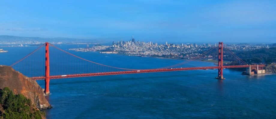
The Golden Gate Bridge is one of the most recognizable landmarks in the United States and one of the world’s most celebrated examples of bridge engineering. Stretching across the Golden Gate Strait between San Francisco and Marin County, the bridge connects the city with communities north of San Francisco while providing spectacular views of the Pacific Ocean, San Francisco Bay and the surrounding California landscape.
Opened in 1937, the bridge was an extraordinary engineering achievement for its time. Its 4,200-foot (1,280-meter) main span made it the world’s longest suspension-bridge span when it opened, and its 746-foot (227-meter) towers created an equally impressive skyline.
Today, the Golden Gate Bridge is much more than a transportation link. It is a major tourist attraction, an architectural icon, a popular walking and cycling destination, and a symbol of San Francisco itself.
Where Is the Golden Gate Bridge?
The Golden Gate Bridge crosses the Golden Gate Strait, the narrow entrance connecting the Pacific Ocean with San Francisco Bay. The bridge’s southern end is in San Francisco, while its northern end reaches Marin County near the communities of Sausalito and Fort Baker.
The name “Golden Gate” does not refer to the bridge’s orange color. It comes from the name of the strait itself. The Golden Gate Strait was historically known as “Chrysopylae,” meaning “Golden Gate.”
The location is particularly dramatic because the bridge stands between steep coastal landscapes, open ocean, cliffs and the urban skyline of San Francisco.
History of the Golden Gate Bridge
The idea of crossing the Golden Gate
For many years, the Golden Gate Strait was considered a formidable natural barrier. Before the bridge was constructed, people traveling between San Francisco and Marin County generally depended on ferries.
The idea of constructing a bridge across the strait appeared as early as 1872, when railroad entrepreneur Charles Crocker proposed the concept. However, the project was considered extremely difficult because of the strait’s width, depth, strong currents, winds and exposure to the Pacific Ocean.
As San Francisco and the surrounding Bay Area grew, the demand for a permanent transportation connection increased.
By the 1920s, public support for the project had become much stronger. The campaign became associated with the slogan “Bridge the Gate.” In 1928, the Golden Gate Bridge and Highway District was established to finance, build and operate the bridge.
Joseph Strauss and the bridge project
Engineer Joseph B. Strauss became one of the central figures behind the project. He had a vision of constructing a suspension bridge capable of crossing the enormous opening of the Golden Gate.
The project faced substantial opposition.
Ferry companies feared that a bridge would destroy their business. Some environmentalists and conservationists were concerned that the bridge would damage the spectacular natural landscape. There were also engineers who questioned whether such a large suspension bridge could safely withstand the area’s winds, currents and earthquakes.
Strauss assembled a team of specialists in engineering, architecture and construction to solve these problems.
Among the important contributors were engineers and designers who helped transform the project from an ambitious idea into a practical structure.
Construction of the Golden Gate Bridge
Construction officially began on January 5, 1933.
Building the bridge during the Great Depression was a remarkable economic and engineering undertaking. The project employed thousands of workers directly and indirectly and provided an important source of employment during a period of severe economic hardship.
Construction lasted a little more than four years. The bridge opened to pedestrians on May 27, 1937, followed by vehicular traffic on May 28, 1937.
The official construction cost was approximately $35 million, a huge amount for the period.
Golden Gate Bridge Engineering
The Golden Gate Bridge is a suspension bridge. Its roadway is suspended from two enormous main cables, which pass over the tops of the two towers and are anchored at either end.
Key engineering statistics
| Feature | Measurement |
|---|---|
| Main span | 4,200 ft / 1,280 m |
| Total bridge length including approaches | 8,981 ft / 2,737 m |
| Suspension span | 6,450 ft / 1,966 m |
| Bridge width | 90 ft / 27 m |
| Roadway width | 62 ft / 19 m |
| Tower height above water | 746 ft / 227 m |
| Roadway clearance above water | 220 ft / 67 m |
| Main cable diameter | 36⅜ in / 0.92 m |
| Construction period | 1933–1937 |
| Original construction cost | $35 million |
When completed, its 4,200-foot main span established a world record for suspension bridges.
The Massive Suspension Cables
One of the most remarkable aspects of the Golden Gate Bridge is its main cables.
Each main cable is approximately 7,650 feet (2,332 meters) long and about 36⅜ inches (0.92 meters) in diameter.
Each cable contains 27,572 individual wires. Together, the two main cables contain approximately 80,000 miles of galvanized steel wire.
The cables carry enormous loads from the roadway and transfer those forces to the towers and massive anchorages.
The engineering principle is relatively simple in concept but extraordinarily complex in execution: the roadway is suspended from vertical suspender ropes connected to the main cables, while the cables transfer their loads through the towers to the anchorages.
Why Is the Golden Gate Bridge Orange?
Perhaps the bridge’s most distinctive feature is its color.
The Golden Gate Bridge is painted International Orange, rather than gold or the traditional gray often associated with steel bridges.
The color was carefully selected partly because it complements the surrounding landscape and partly because it makes the bridge more visible in the frequent San Francisco fog. Architect Irving Morrow played an important role in selecting the distinctive color.
The orange-red color has since become inseparable from the identity of San Francisco.
The Bridge and San Francisco’s Landscape
The Golden Gate Bridge is unusual because its visual impact comes not only from the structure itself but also from its setting.
On clear days, visitors can see:
- San Francisco Bay
- The Pacific Ocean
- Marin Headlands
- Alcatraz Island
- San Francisco’s skyline
- Sausalito
- Fort Baker
- Angel Island
- Coastal cliffs and beaches
Fog can completely transform the appearance of the bridge. Sometimes only the upper sections of the towers are visible above the clouds, creating one of the most characteristic views associated with San Francisco.
Walking Across the Golden Gate Bridge
Walking across the bridge is one of the most popular San Francisco experiences.
The bridge extends approximately 1.7 miles (2.7 km) including its approaches, and visitors can walk across the entire structure.
A walk from the San Francisco side toward Marin County provides constantly changing views of the city, bay, ocean and bridge itself.
What to expect
A round trip can take several hours if you stop frequently for photographs and viewpoints. The experience can be considerably longer on windy or foggy days.
The bridge can also be surprisingly cold, even when San Francisco itself feels relatively mild. Strong winds are common, so a jacket or wind-resistant layer is recommended.
Cycling Across the Bridge
Cycling is another excellent way to experience the Golden Gate Bridge.
The bridge connects directly with bicycle routes on both sides, allowing visitors to combine a bridge crossing with a trip through the Presidio, Marin Headlands or Sausalito.
A popular itinerary is:
San Francisco → Golden Gate Bridge → Sausalito → ferry back to San Francisco
This combines cycling, sightseeing and a ferry ride across the bay.
Cyclists should pay close attention to pedestrian and bicycle regulations because the sidewalk arrangements and permitted directions can vary.
Best Places to See the Golden Gate Bridge
One of the best things about visiting the Golden Gate Bridge is that there are numerous viewpoints rather than a single designated observation area.
1. Golden Gate Bridge Welcome Center
The Welcome Center on the San Francisco side is a convenient starting point for visitors.
It provides information about the bridge and the surrounding area and serves as an access point for exploring the bridge and nearby viewpoints.
2. Battery Spencer
Battery Spencer on the Marin County side is one of the most famous viewpoints of the bridge.
From the elevated position, visitors can see the entire bridge stretching toward San Francisco, with the city skyline behind it.
It is particularly popular for photography around sunrise, sunset and during periods of dramatic fog.
3. Fort Point
Fort Point sits directly beneath the southern end of the Golden Gate Bridge.
The historic military fort dates from the 19th century and was carefully preserved during construction of the bridge. Joseph Strauss designed a special arch structure so the bridge could pass over Fort Point rather than requiring the fort to be demolished.
This makes Fort Point an especially interesting location for visitors interested in both military history and engineering.
4. Crissy Field
Crissy Field provides a broad waterfront perspective looking toward the Golden Gate Bridge.
The area is excellent for walking, cycling, picnicking and photography. On clear days, the combination of beach, bay, bridge and Marin Headlands creates an impressive panorama.
5. Baker Beach
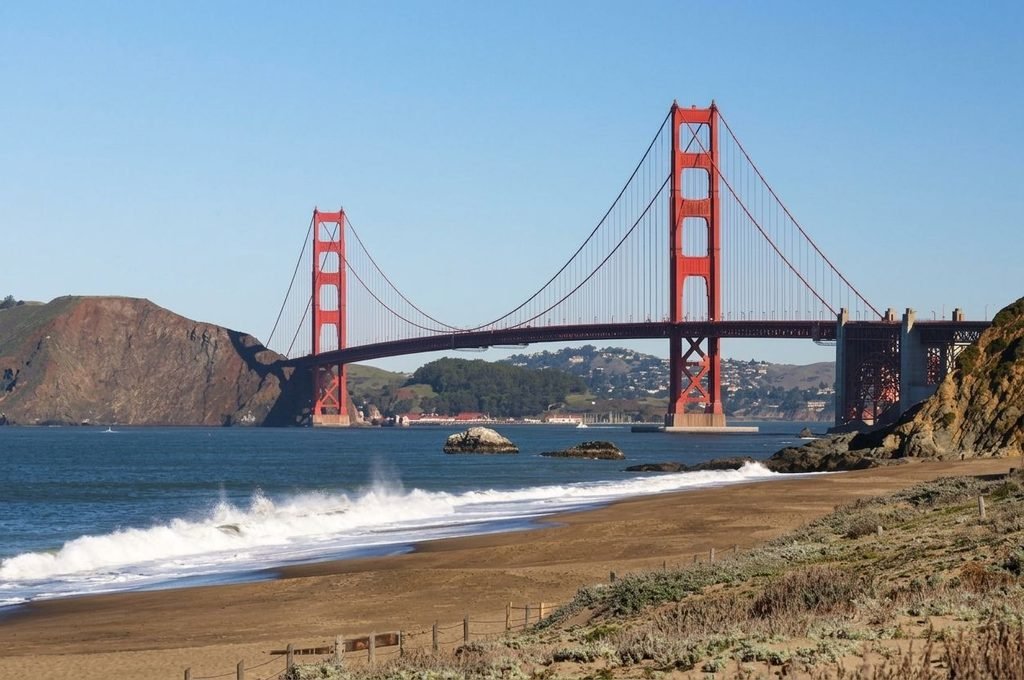
Baker Beach is one of the classic locations for photographing the Golden Gate Bridge from the ocean side. The beach provides a lower and more dramatic perspective than the viewpoints around the bridge plaza. It is especially popular during late afternoon when the bridge and surrounding cliffs can be illuminated by warm light.
6. Marin Headlands
The Marin Headlands offer some of the most spectacular elevated perspectives of the Golden Gate Bridge.
Several viewpoints overlook the entire bridge, the strait and San Francisco.
The area is particularly attractive for photographers, hikers and visitors looking for a more natural environment away from the city.
Golden Gate Bridge and the Presidio
The San Francisco end of the bridge is closely associated with the Presidio, a historic military landscape that is now part of the Golden Gate National Recreation Area.
The Presidio combines:
- Historic military buildings
- Forests
- Coastal trails
- Beaches
- Scenic viewpoints
- Museums
- Historic roads
- Recreational areas
The National Park Service describes the Golden Gate National Recreation Area as a major urban park system containing extensive natural, cultural and historic landscapes around the Bay Area.
For travelers, this means that the Golden Gate Bridge can easily be combined with several hours of sightseeing in the Presidio.
Golden Gate Bridge and Fort Point
Fort Point has a particularly fascinating relationship with the bridge.
The fort was built to defend the entrance to San Francisco Bay, but by the 20th century it had become obsolete as a coastal defense installation.
When plans for the Golden Gate Bridge were developed, demolition of Fort Point was initially considered. Strauss recognized the architectural importance of the fort and modified the bridge design to preserve it.
Today, visitors can stand inside the historic fort and look upward at the enormous steel structure passing overhead.
Golden Gate Bridge During Fog
Fog is one of the defining characteristics of the Golden Gate.
The strait’s location between the Pacific Ocean and San Francisco Bay creates atmospheric conditions that frequently produce fog.
When fog rolls through the bridge, the structure can appear and disappear within minutes.
Sometimes:
- The entire bridge is visible beneath a layer of fog.
- Only the towers emerge above the fog.
- The cables disappear into the clouds.
- The orange towers contrast dramatically with the gray atmosphere.
For photographers, these changing conditions can create very different images of the same landmark throughout a single day.
The Golden Gate Bridge and Earthquakes
Because California is seismically active, earthquake resistance has always been an important consideration for the bridge.
The Golden Gate Bridge survived the 1989 Loma Prieta earthquake without structural damage, even though the earthquake caused major disruption elsewhere in the Bay Area.
The bridge has subsequently undergone extensive seismic and structural improvements designed to increase its ability to withstand major earthquakes.
The National Park Service notes that the bridge is being retrofitted for resilience against an earthquake of magnitude 8 or greater.
How the Golden Gate Bridge Moves
Although the bridge appears rigid, it is actually designed to move.
Suspension bridges must be flexible enough to respond to:
- Wind
- Traffic
- Temperature changes
- Earthquake movement
- Structural loads
According to the Golden Gate Bridge and Highway District, the bridge can move vertically and laterally by significant amounts. At the center of the span, it can move downward by as much as approximately 10.8 feet or upward by about 5.8 feet, while side-to-side movement can reach approximately 27.7 feet.
This flexibility is an essential component of the bridge’s structural design.
Driving Across the Golden Gate Bridge
The bridge carries U.S. Highway 101 and California State Route 1 across the Golden Gate.
It remains a major transportation corridor connecting San Francisco with Marin County and destinations farther north.
The bridge carries millions of vehicles annually; the Golden Gate Bridge District reports roughly 39–40 million vehicle crossings per year.
One important point for drivers is that toll collection is electronic.
Golden Gate Bridge Toll
The Golden Gate Bridge currently collects tolls only in the southbound direction, meaning motorists entering San Francisco pay the toll while northbound traffic does not.
As of July 1, 2026, the standard two-axle rate is:
| Payment method | Two-axle vehicle |
|---|---|
| FasTrak | $10.25 |
| License Plate Account / One-Time Payment | $10.50 |
| Toll Invoice | $11.25 |
Motorcycles are included in the two-axle category.
The bridge no longer accepts traditional cash toll payments at toll booths. Electronic tolling allows vehicles to pass without stopping.
Golden Gate Bridge for Tourists
The bridge is suitable for many different types of travelers.
Families
Families can combine a bridge visit with the Presidio, Crissy Field, nearby beaches and other San Francisco attractions.
Photographers
The bridge offers countless perspectives, particularly from Battery Spencer, Baker Beach, Fort Point, Crissy Field and the Marin Headlands.
Cyclists
Cyclists can cross the bridge and continue toward Sausalito and Marin County.
Hikers
The surrounding parks and headlands provide extensive walking and hiking opportunities.
Architecture and engineering enthusiasts
The bridge offers an extraordinary opportunity to see a historic suspension bridge at close range and understand how its towers, cables and roadway work together.
Best Time to Visit the Golden Gate Bridge
There is no single perfect time because the bridge looks dramatically different under different weather conditions.
Early morning
Morning can provide quieter conditions and softer light. Fog is also possible, particularly during certain weather patterns.
Midday
Midday generally provides better visibility when the weather is clear, but popular viewpoints can be busier.
Late afternoon
Late afternoon offers excellent photographic conditions as the light changes across the bridge and surrounding landscape.
Sunset
Sunset can produce spectacular colors, particularly when viewed from locations on the western side of San Francisco.
Foggy days
Fog should not necessarily be considered bad weather. For many visitors and photographers, fog is part of the Golden Gate experience.
Golden Gate Bridge Photography Tips
The bridge is one of the world’s most photographed structures, but visitors can still find distinctive compositions.
Consider photographing it from:
- Below at Fort Point
- Baker Beach
- Crissy Field
- The Presidio
- Golden Gate Bridge Plaza
- Battery Spencer
- Marin Headlands
- Along the waterfront
- Sausalito
A wide-angle lens is useful for capturing the entire bridge, while a telephoto lens can compress the bridge and San Francisco skyline into a dramatic composition.
Fog, clouds and changing light can be used creatively rather than treated as obstacles.
Nearby Attractions
A visit to the Golden Gate Bridge can easily be combined with several other major attractions.
Presidio
Historic military grounds, forests, trails and coastal scenery.
Crissy Field
A waterfront recreational area with excellent bridge views.
Fort Point National Historic Site
A historic coastal fort located directly beneath the bridge.
Baker Beach
A scenic Pacific Ocean beach with a famous view toward the bridge.
Palace of Fine Arts
A monumental architectural landmark located relatively close to the bridge.
Lombard Street
One of San Francisco’s best-known streets, famous for its steep, winding section.
Fisherman’s Wharf
A major waterfront tourism district with restaurants, shops, attractions and access to bay cruises.
Alcatraz Island
The former federal penitentiary located in San Francisco Bay.
Sausalito
A waterfront town on the Marin County side that makes an excellent addition to a Golden Gate Bridge itinerary.
Golden Gate Bridge and San Francisco Tourism
The Golden Gate Bridge is central to San Francisco’s international tourism identity.
Unlike many attractions that require visitors to enter a building or purchase a ticket, the bridge itself can be experienced from numerous public locations.
Visitors can:
- Walk across it
- Cycle across it
- Drive across it
- Photograph it
- View it from beaches
- View it from parks
- See it from boats
- Explore the surrounding historical sites
- Combine it with a trip to Marin County
This accessibility is one of the reasons the bridge remains such a powerful tourist attraction.
Golden Gate Bridge as an Engineering Icon
The Golden Gate Bridge represents a remarkable combination of engineering, architecture and landscape design.
Its significance is not simply that it is large. Its importance comes from the way engineers overcame a combination of difficult conditions:
- A wide strait
- Deep water
- Strong currents
- High winds
- Heavy fog
- Earthquake risk
- Difficult geological conditions
- A demanding construction environment
The result was a bridge that was technologically advanced in the 1930s while also fitting remarkably well into the surrounding landscape.
Interesting Facts About the Golden Gate Bridge
- The bridge opened in 1937.
Pedestrian Day was held on May 27, followed by vehicular traffic on May 28. - Its main span is 4,200 feet long.
That was a world record when the bridge opened. - The towers are 746 feet high.
- The bridge is not gold.
Its official color is International Orange. - The Golden Gate name belongs to the strait.
It does not describe the bridge’s color. - Each main cable contains 27,572 wires.
- The two main cables contain approximately 80,000 miles of wire.
- The bridge is flexible by design.
It can move significantly under wind and other forces. - Fort Point was preserved because of the bridge.
Strauss modified the design to pass over the historic fort. - The bridge survived the 1989 Loma Prieta earthquake without damage.
- Pedestrians once paid to cross the bridge.
The pedestrian toll was eliminated in December 1970. - The bridge still serves as a major transportation route.
Approximately 39–40 million vehicles cross it annually.
A Suggested Golden Gate Bridge Day Trip
A full day can be devoted to the bridge and its surrounding attractions.
Morning
Start at the Golden Gate Bridge Welcome Center and walk across the bridge toward Marin County.
Late morning
Continue toward Fort Baker or travel onward to Sausalito.
Lunch
Have lunch in Sausalito or return toward San Francisco.
Afternoon
Explore the Presidio and Crissy Field, then visit Fort Point.
Late afternoon
Head toward Baker Beach for another perspective of the bridge.
Sunset
Finish the day at one of the elevated viewpoints around the Marin Headlands, depending on accessibility and weather.
This itinerary provides views from both sides of the bridge and demonstrates why the Golden Gate is much more than a single photographic landmark.
Practical Travel Tips
- Bring a jacket: Wind can make the bridge considerably colder than expected.
- Check visibility: Fog can dramatically change the experience.
- Allow extra time: Photographers and walkers will naturally spend longer than drivers.
- Use multiple viewpoints: The bridge looks completely different from Fort Point, Baker Beach and Marin Headlands.
- Consider combining the visit with Sausalito: Crossing the bridge and continuing into Marin County makes an excellent half-day or full-day excursion.
- Check current pedestrian and bicycle access rules before visiting: Operating arrangements can change.
- If driving, remember the toll direction: Current toll collection is southbound only.
- Do not rely on a single viewpoint: Some of the most memorable Golden Gate Bridge views are away from the main visitor plaza.
Why the Golden Gate Bridge Is So Important
The Golden Gate Bridge has become much more than a piece of transportation infrastructure.
It represents the transformation of San Francisco during the 20th century, the engineering ambitions of the Great Depression era and the city’s relationship with the Pacific coast.
Its distinctive International Orange towers, enormous suspension cables and dramatic setting have made it one of the most recognizable structures in the world.
Even more than eight decades after its opening, the bridge remains a functioning transportation link while simultaneously serving as a historic landmark, tourist attraction, photography destination and symbol of San Francisco.
For anyone visiting Northern California, experiencing the Golden Gate Bridge from several different perspectives—walking across it, viewing it from the waterfront, seeing it from the Marin Headlands and exploring historic Fort Point—provides a much richer experience than simply taking a photograph from the main plaza.
The Golden Gate Bridge is ultimately a rare combination of engineering achievement, architectural beauty, natural landscape and cultural identity. Its spectacular setting and extraordinary history explain why it remains one of America’s most famous landmarks and one of the defining symbols of San Francisco.